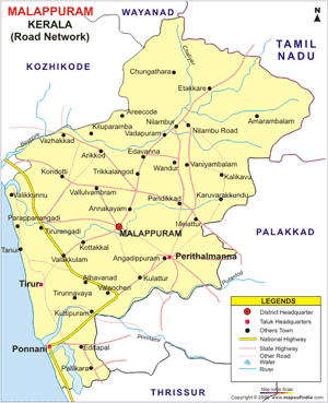
About Malappuram
 Malappuram is a municipality and administrative headquarters of Malappuram district in the South Indian state of Kerala. Malappuram (literally a land atop hills) is situated 50 km southeast of Kozhikode. Bounded by the Nilgiri hills on the east, the Arabian Sea on the west and Thrissur and Palakkad districts on the south. Malappuram is situated on the Kozhikode (Calicut) – Chennai road (NH 213), 12 km southwest of Manjeri and 50 km southwest of Kozhikode.
Demographics
As of 2001 India census, Malappuram had a population of 58,490. Males constitute 49% of the population and females 51%. Malappuram has an average literacy rate of 80%, higher than the national average of 59.5%: male literacy is 82%, and female literacy is 79%. In Malappuram, 15% of the population is under 6 years of age.
Geography
The Nilgiri Hills of Tamil Nadu in the east and the Arabian Sea in the west, provide natural boundaries. In the north, it is bounded by Kozhikode and Wayanad and in the south, by Palakkad and Thrissur districts. The topography of Malappuram consists of three natural divisions; lowland, midland and highland. The low land stretches along the sea coast, the midland in the centre and the highland region towards the east and north eastern parts, rich with evergreen forests, ravines, hills and dales, rivers and brooks. The topography of the district is highly undulating; starting from the hill tops covered with thick forests on the east along the Nilgiris, it gradually slopes down to the valleys and the small hills, before finally ending on the sandy flat of luxuriant coconut groves and palm fringed coasts in the west.
Administration
Malappuram district was formed on the 16th June 1969, amalgamating the distant and backward areas of the erstwhile Kozhikode, Perintalmanna and Ponnani taluks of Palakkad. There are 6 taluks, namely Ernad (headquarters at Manjeri), Perinthalmanna, Tirur, Ponnani, Nilambur and Tirurangadi (headquarters at Parappanangadi)
Tourism
Kottakkunnu is a very beautiful Tourist location in Malappuram district, Kerala. At Kottakkunnu one can see traces of the first fort to be built by the Zamorins(Samoothiri) of Kozhikode. This scenic table-top location is located at the crest of the Cantonment Hill near the district collectorate. The Vettakkorumakan Temple and the Siva Temple with the famous murals of Malabar are nearby.
Malappuram at a glance
Found : 1960 June 16 | Area : 3550 Km | Population : 36,29,690 | Men : 18,70,161 | Woman : 17,59,479 | Density : 1022 | Literacy : 88.61%
Lakes
Bharathappuzah, Kadalundippuzha, Chaliar, Tiruppuzha
Border
East : Nilgiri, West : Arabian Sea, South : Kozhikkode Vayanad Districts, North : Palakkad, Thrissur Districts
Parliamentary Constituents
Ponnani, Malappuram, Vayand (Partial)
Legislative Assemblies (16)
Malappuram, Kondotty, Manjeri, Nilambur, Vandoor, Mankada, Perinthalmanna, Ponnani, Tirur, Tirurangadi, Tanur, Kottakkal, Tavanur, Vengara, Eranad, Vallikkunnu, District Panchayath Divisions (32), Block Panchayaths (14) Total Panchayaths (102)
Municipalities
Kondotty, Kottakkal, Malappuram, Manjeri, Nilambur, Parappanangadi, Perinthalmanna, Ponnani, Tanur and Tirur
Revenue Division
Eranad, Nilambur, Perinthalmanna, Ponnani, Tirur, Tirurangad
Taluk
Perinthalmanna, Tirur, Villages (133)


